- You have no items in your shopping cart
- Continue Shopping
$ 90.35
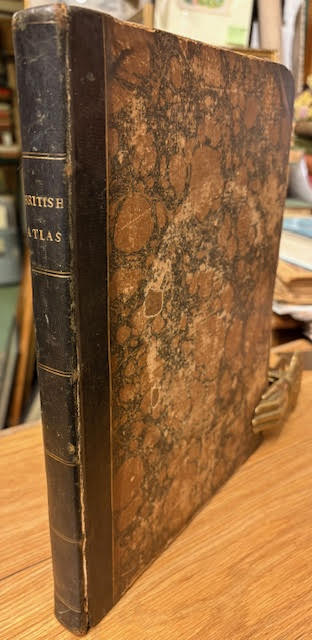
79 plates. Contemporary half black morocco over marbled boards, with gilt ruling to spine and boards and lettering to spine. With 58 maps in colour and 21 plans in black and white (plates complete). Spine and boards rubbed and corners bruised. Splitting to the front board at hinge which is a risk of seperating. Foxing and some staining throughout. With pressed flower petal leaves scattered throughout. Inscription to first free endpaper and an postal label to the front pastedown with an ink descripton about previous ownership inscription. Title: The British Atlas; Comprising A Complete Set of County Maps of England and Wales; With A General Map of Navigable Rives and Canals; and Plans of Cities and Principal Towns. Author Name: [Cole, George] Edition: First Edition Location Published: London, Printed for Vernor, Hood, and Sharpe; Longman, Hurst, Rees, and Orme; J. Harris; J. Cuthell; J. Cundee; W. Faden; J. and A. Arch; Crosby and Co.; J. Richardson; and J. M. Richardson 1810: 1810 Binding: Half Morocco Book Condition: Very Good Size: 4to. Map Categories: British Topography and Local History, Plate Books, Maps and Atlases Book number: 70163 Keywords: britain, georgian, maps, plates
Related products